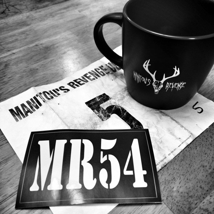
June 23-24, 2018. MR54 Mile Ultra.
“Does it make it easier the second time around?” Hell, No!
“Does it make is sweeter the second time around?” Oh Yeah!
I’ve done this last year – read the experience here. The goal this year is the same goal I’ve set last year. I didn’t achieve the goal last year, but was happy to have finished without any injuries. Would it be different this year?
MR54 – a point-to-point 54.3 mile ultra from Windham, NY @ CD Lane Park to Phoenicia, NY @ downtown Parish Hall, traversing the technical trails of the Long Path/Escarpment trail and Devil’s Path. Considered as one of the most difficult and technical 50 miler in the Beast Coast, if not the entire country. Agree/Disagree?
Prologue.
My friends, Philip and Ryan, and myself, did an exploration hike on Devil’s Path 2 weeks before the race. We did the full (Eastern) Devil’s Path in 6 hours. That was with fresh legs. The Devil’s Path section of MR54 would be after 31 miles on race day!
Friday-Sunday. Philip and I stayed @ Black Bear Campground, right in the Phoenicia downtown area. Very convenient place to stay for the event – walking distance to the shuttle pickup on race day, and also from the finish after the race. We’ve met so many runners staying in the same campground. Our friend, Ryan, had a more luxurious accommodation, complete with ‘Uber’ before and after the race 🙂
Saturday. Race Day. 3AM. Philip and I walked to the lot behind the Phoenicia pharmacy for the 3:30AM shuttle pickup. It was about an hour drive to the start, @ CD Lane Park. Two buses full of crazy dudes and dudettes, plus the ones already waiting at the start, doing this crazy event for their own personal masochistic reasons.
Weather forecast was rain with occasional thunderstorms. I thought this would make the race miserable. This would turn out to be better than last year’s weather. Last year was humid, with wet and muddy trails; this year, spotty rain, but with favorably dry trails.
I was on wave 5, same as last year. There were 8 waves, each wave starting 5 minutes apart. The 1st wave started at 5AM, and at 5:20AM, our wave took off!
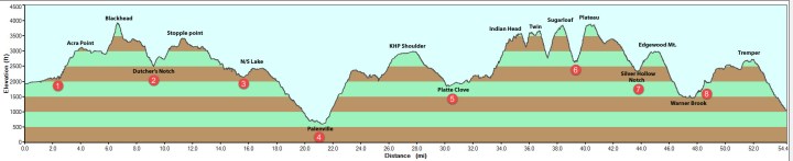
The first 3 miles was on the road leading to the trail head. This was the warm-up section. We just jogged, with occasional chit-chat, before hitting the trail where the fast ones really took off. The trail starts off with the first climb, Acra Point, followed immediately by Blackhead Mtn, the highest point in the course, and the first of the 5 Catskill 3500 Peaks in this course. Climbing the Blackhead Mtn, Ryan passed me. He was on wave 7 (10 minutes behind me on the start)! And we were on the first 8 miles of the course! He definitely was not seeded correctly! I enjoyed the company of Chris and Joe in the first (few) miles leading to the Dutcher’s Notch aid station (AS#2-10mi). Another climb to Stoppel Point, and a good runnable section to the next aid station @ North-South Lake (AS#3-17mi).
Note! The site of the Piper plane crash in 1983 is in the section between Dutcher’s Notch and Stoppel Point, on the last climb before the Stoppel Point lookout. This section also has lots of vantage points for photo opportunities. One lookout offers the complete view of the Devil’s Path peaks (which is part of this course @ mile 31-40).
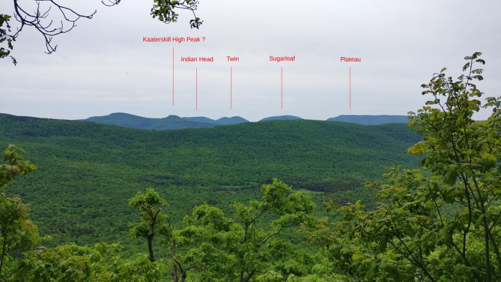
A really good downhill section follows the North-South Lake aid station (AS#3-17mi) all the way to the Palenville aid station (AS#4-21mi). This was a good 3+ miles of blissful downhill. However, what follows next is longest section between aid stations – Palenville (AS#4-21mi) to Platte Clove (AS#5-31mi). A 10 mile gap, with the never ending climb on the Kaaterskill High Peak. I call this the ‘Drag’ section. The climb was not technical – it was just never ending! Even the ‘runnable’ section at the top was not really runnable, with lots of roots and mushy ground. The only relief was that the trail was dry. This section was a mudfest last year. This was also the section where more runners had either left me or passed me. Talk about a demoralizing section!
I reached the Platte Clove aid station (AS#5-31mi), about the same time I reached it last year (8:20hrs)! Changed clothes, re-supplied, and made sure I had my headlamp on before leaving the AS. I ‘overstayed’ in the aid station that the crowd gave me some cheers when I left :). Big thanks to ‘grandpa’ at the aid station for his watchful eyes, making sure I had everything.
Now the real fun begins. Devil’s Path – 3 Catskill 3500 Peaks to the next aid station @ Mink Hollow (AS#6-38mi). The most technical section of the course, where both hands and proper footing are essential in both ascents and descents. I’ve hiked these peaks a few times. I’ve always enjoyed these technical trails (Note – this does not equate to being fast on this section!). I was just comfortable in both the (slow) ascents and (having-fun) descents.
I really had fun in this section, leap-frogging with Elizabeth and Allan, Brittany and Ryan, on the ascents and descents. Every second I gained on the descent, they took back on the ascent. Boy, do I suck in climbing! I jokingly said at one point, “Gravity is my friend. I enjoy playing with it on the descent, it enjoys toying with me more on the ascent.”
The last Catskill 35er peak, Plateau Mtn, comes after the Mink Hollow aid station (AS#6-38mi), finally leaving the Devil’ Path section after a short mile at the summit, turning left to Long Path heading towards Tremper/Phoenicia. A good runnable section heading to the next aid station @ Silver Hollow (AS#7-43mi). It was at this point that I began to think my goal was achievable. Really?
Such a relief getting to this aid station (AS#7-43mi), with tired legs but still with high spirit. Saw Rica volunteering at the aid station. Two more peaks. Not technical, but it would be dark navigating the trails. And these trails follow some really confusing twists and turns. Once again, the group of runners I’ve passed on the descent to the aid station either left or passed me on the climbs. Crap!
I’ve reached the Willow aid station (AS#8-48mi) past 9PM. With just 2+ miles of climbing to the Fire Tower, and the 3 mile rocky descent, then 1+ mile of road to the finish, I started to believe more I could achieve my goal. So, after a quick refill, I continued. This was my quickest stop at all aid stations. At this point, too, I was just so comfortable walking alone and navigating the dark trails. Took a short break when I reached the tower and did a mental check if the goal was still possible. Still possible, but I need to ‘run’ from here to the finish. The next section was the rocky downhill where I slipped and fell twice last year. Last year, I walked the rest of the course after the 2nd fall, happy to finish without injuries. This time, I needed to run the rest of the course. Ok – “Run cautiously on this descent, and do another mental check when you reach the road”, I said. No slip, no fall, no stop. Reached the road with legs totally trashed. But no stopping now. “Trust. Believe. Try”. So I ran the last mile, sprinting when I finally saw the finish, and almost collapsed when I crossed the finish. Totally wasted, but was so happy to have achieved the goal!
Epilogue.
I have been repeating this phrase to myself this past month for a different reason. This day, I’ve used it to achieve the goal that I’ve set last year – sub 18hrs. “Teach me to trust in You, with all of my heart… I just forget, You won’t give me what I can’t bear.” The phrase is from a song by Gary V, a popular Filipino artist. And in the last 10 miles or so, when my whole body was hurting, I have these words in my mind – “Trust in You. Believe. Try”. So I did, and I finished MR54 in under 18 hours. Once again, Thank You.
Thank you, Charlie and your band of volunteers! This is one event that will always be in my calendar. June 22-23, 2019, you say?
Gear and Nutrition.
- Salomon vest with 50oz bladder (water) + 2 600ml flasks (tailwind+carbopro mix)
- Salomon shirt + Salomon bonatti jacket
- CWX compression tights + cheap shorts over + light calf compression
- UD groove belt (easy access for gels and pills)
- Hoka Speedgoat 2 + Drymax socks
- BD Poles + cheap gardening gloves
- Ledlenser MH10 headlamp + MT10 handheld (as backup)
- Pre-packed tailwind+carbopro refills
- Carbopro pills (vo2max, motivator, metasalt, amino recovery)
- Untapped maple syrup gels
- my nutrition allowed me not to get food from aid stations (ok – except for some potatoes and salt)


One thought on “Manitou’s Revenge 54 Mile Ultra”